
Google Earth Pro Overview
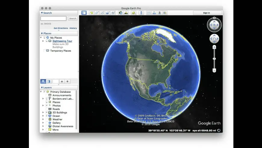
Google Earth Pro for Mac is a desktop 3D mapping and geographic visualization app for exploring satellite imagery, 3D terrain, buildings, and Street View. Its Pro desktop tools go beyond basic globe browsing by letting users work with geographic data, historical imagery, measurements, and map outputs.
For users working with location data, Google Earth Pro can import spreadsheet coordinates, GIS imagery, vector data, and other supported geographic formats, then organize the resulting information in its Places and 3D viewer workflow. It also supports KML and KMZ projects, making it useful for geographic research, location analysis, education, planning, and presentation work. Google currently lists version 7.3.7 for Mac, while its desktop documentation continues to identify Intel 64-bit as the Mac processor requirement.
Why Choose Google Earth Pro Mac App?
Google Earth Pro is worth choosing when you need more than a standard online map. Its strongest distinction is the desktop geographic-data workflow: you can bring location information, GIS imagery, vector data, and spreadsheet coordinates into the application, inspect that information in a 3D environment, organize it through Places, and save geographic work as KML or KMZ files. Several of these import capabilities are specifically identified by Google as Google Earth Pro features.
It is also particularly useful when time and location need to be analysed together. Historical imagery lets you examine how a place has changed, while measurement tools, Street View, 3D terrain, map-image output, and the desktop Places workflow turn the globe into a practical research and visualization tool. Google positions the desktop Pro version for users with advanced feature needs, including GIS import/export and historical imagery.
Features
- Historical Imagery — Browse available imagery from different dates to examine changes at a location over time.
- GIS Data Import — Import supported geographic imagery and vector datasets into the desktop 3D viewer, including GeoTIFF, TIFF, NTF, IMG, SHP, and other supported formats.
- Spreadsheet Data Import — Bring CSV or delimited location data into Google Earth Pro and convert geographic records into placemarks.
- KML and KMZ Support — Open, organize, and save geographic projects using Google’s KML/KMZ format, including workflows for moving Pro data into newer Google Earth environments.
- 3D Terrain and Buildings — Explore geographic locations using three-dimensional terrain and available 3D building imagery.
- Street View — Open Street View imagery from supported locations directly within Google Earth Pro. Google requires version 7.3.3 or newer for Street View access.
- Measurement Tools — Measure geographic features and distances directly within the desktop application.
- Save Image — Create map images from the current Earth view for documentation, presentations, or other visual output.
- Places and My Places — Organize saved locations, imported datasets, placemarks, paths, and other geographic content into folders.
- Movie Maker — Record geographic tours and navigation as video using the Pro desktop workflow. Google has continued improving Movie Maker in recent releases.
What’s New in 7.3.7 Version
Google’s current release notes identify Google Earth Pro 7.3.7 as the latest desktop release. The update is focused mainly on KML compatibility, geographic-data interoperability, measurement consistency, and fixes.
- Google Earth 10 KML compatibility — Improves how KML exported from Google Earth 10 works with Google Earth Pro.
- gx:CascadingStyle support — Adds support for this KML extension.
- KML styling preservation — Imported KML features can retain icons, line widths, and colors from Google Earth 10 exports.
- Additional KML extensions — Improves compatibility with other extensions found in KML files exported from Google Earth 10.
- Measurement consistency — The Measurement tool and Property Editor measurement tab now use the same unit selection.
- GeoTIFF and super overlay KMZ support — Imported GeoTIFF imagery or super overlays can be saved as KMZ files that can be opened in Google Earth 10.
- Additional fixes — The release also includes other minor fixes and improvements.
For users moving geographic projects between Google Earth Pro and newer Google Earth versions, the KML and KMZ compatibility improvements are the most relevant part of this release.
Supported macOS Versions
Google's current documentation lists Mac OS 10.8 or later as the supported baseline for Google Earth Pro and specifies a 64-bit Intel processor for the Mac version. The current desktop installer is also identified as an Intel Mac package.
For modern Macs, the processor architecture is therefore more important than simply checking the macOS release number. Google's published documentation does not currently identify a native Apple Silicon build, so users with M-series Macs should verify compatibility before installing the desktop Pro version.
For supported Intel Macs, Google Earth Pro remains suitable for its desktop mapping workflow, including 3D geographic exploration, historical imagery, Street View, geographic-data import, and KML/KMZ projects. Users working with particularly demanding 3D or GIS projects should use a Mac that comfortably exceeds Google's minimum configuration.
How to Download and Install Google Earth Pro on Mac?
Installing Google Earth Pro on Mac only takes a few steps after downloading, including one quick permission it needs to run properly.
- Click the Download button given above to download the official setup file.
- Open the downloaded .dmg package file in your Downloads folder.
- Run the .pkg installer inside and follow the step-by-step installation wizard.
- Launch Google Earth Pro from your Applications folder or via Spotlight.
- If macOS displays a background security prompt, open System Settings → Privacy & Security and select Open Anyway.
- Grant network access permissions when prompted so the app can stream live satellite imagery assets.
Once the initial setup is done, Google Earth Pro won't ask for these permissions again, future launches go straight to the globe dashboard.
How to Use Google Earth Pro on Mac?
- Find a location: Use the Search panel to locate an address, place, landmark, or geographic area.
- Inspect the location: Navigate the 3D view and use available imagery, terrain, and Street View to examine the area.
- Create your working set: Add useful locations, placemarks, paths, or other geographic objects to the Places panel.
- Add external data: Import supported CSV, GIS imagery, vector, or geographic data when your project requires information beyond Google’s built-in map layers.
- Analyze or compare: Use historical imagery and measurement tools when the task involves change over time, distance, area, or geographic relationships.
- Save the result: Keep the project in Places or save supported geographic work as KML/KMZ for later use or transfer to another Google Earth workflow.